Casabonne's Cilicia
A Frontier of Names, Powers, and Passages — Notes Ciliciennes

Fig. 1 · Cilicia in the Achaemenid Period · Cilicie Trachée (west) and Cilicie Plane (east) · after Casabonne
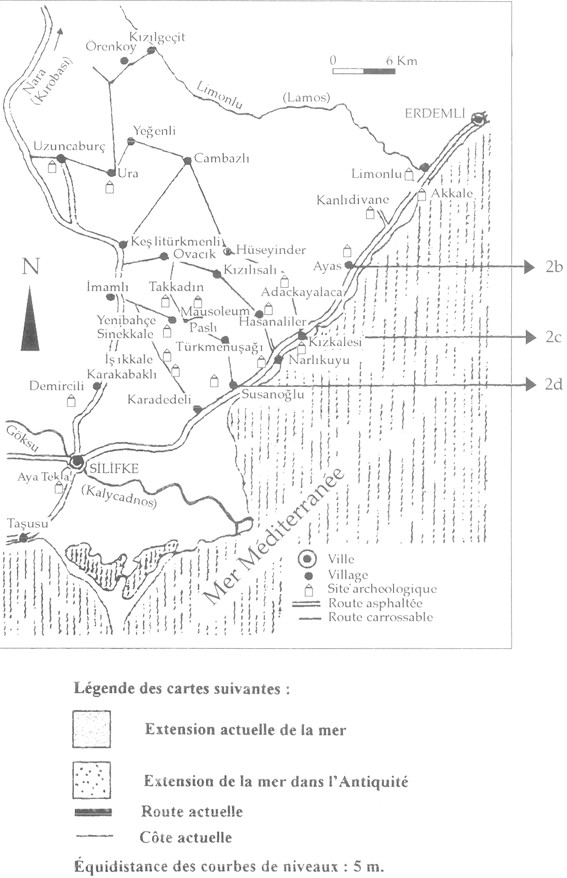
Fig. 2 · The Silifke Region · Rough Cilicia · ancient sites, roads, and coastline · after Casabonne
I. The Name Problem
Casabonne begins with the name "Cilicia" itself — a problem that has generated more hypotheses than resolutions. Earlier scholarship had sometimes derived the regional name from a Semitic root krk, meaning "fortress" or "city," an attractive hypothesis given the strong West Semitic presence in the region. Phoenician and Aramaic were major written languages in Cilicia during the Iron Age and Achaemenid period, and Greek traditions also linked Cilicians with Phoenician or Syrian figures.
Yet Casabonne finds the Semitic derivation insufficient. The expected krk is not clearly attested in the relevant West Semitic inscriptions. He therefore advances an Anatolian — specifically Luwian — explanation: the Greek name "Cilicia" may ultimately derive from Assyrian Hilakku, itself connected with Que/Kue/Kuwe, the Assyrian designation of the Cilician Plain. In this reading, Cilicia's name is not merely imposed from outside, but reflects the adaptation of older local Anatolian terminology into Assyrian, Aramaic, and Greek forms.
II. Cultural Symbiosis and Herodotus' "Hypachaeans"
The linguistic argument connects to a broader cultural interpretation. Herodotus' description of the Cilicians as Hypachaeans is not, for Casabonne, straightforward evidence for Achaean colonisation. Rather, he suggests that Herodotus may be registering Cilicia's intermediate cultural position: neither simply Greek nor simply "barbarian," but a mixed Anatolian-Asian society open to Aegean influence while remaining fundamentally rooted in the Near Eastern and Anatolian world.
Cilicia appears here as a place of cultural symbiosis, where "Asianic," Iranian, Syro-Phoenician, and Greek elements met in the middle of the first millennium BCE. The Achaemenid imperial frame did not dissolve these local identities but organised them within a larger structure of tribute, coinage, and dynastic obligation.
III. Dynastic Identity and Naming Systems
The article turns to individual names and dynastic identities. The name Oromèdôn, known from Herodotus as the father of a Cilician syennesis, is examined as a possible marker of elite acculturation. Casabonne rejects a direct identification with Ahuramazda, but keeps open the possibility that the name is Iranian, adopted by a Cilician aristocrat in dealings with the Persian ruling class. At the same time, he offers an Anatolian alternative, deriving the name from the Hittite-Luwian moon-god Arma.
The point is not simply etymological. Cilician elites under Achaemenid rule may have moved between local and imperial naming systems, expressing different political identities in different contexts — a form of controlled ambiguity that allowed local authority and imperial service to coexist without contradiction.
IV. The Political Geography of Rough Cilicia
A major section reconstructs the political geography of Rough Cilicia, especially the region from the Gulf of Taşucu to the Lykaonian plain. Casabonne gives particular importance to the Periplus of Pseudo-Skylax, which mentions Sarpedon, Holmoi, Aphrodisias, Kelenderis, and Soloi. He argues that this passage implies occupation around Seleucia on the Calycadnus — modern Silifke — before the Seleucid foundation of the city.
The Silifke map (Fig. 2) makes the argument spatial. Sites like Uzuncaburç (ancient Olba), Kizkalesi, Kanlıdivane, and the Göksu river valley are not marginal to the Achaemenid system but integral to it — connected by roads and rivers to the coast and to the inland Taurus passes. The physical landscape is part of the argument.
V. Sarpedon, Ura, and Layered Sacred Topography
Sarpedon is treated not as evidence for a Greek colonial hero cult, but as a name of deep Anatolian resonance, comparable to Mopsos: later Greek legends may have Hellenised a local figure, cult, or toponym already embedded in the landscape. Casabonne associates Sarpedon with the coast near Taşucu, the sandy promontory of Incekum Burnu, and the later Christian landscape of Saint Thecla. In this reconstruction, pagan memory, heroic legend, oracle, tomb, and Christian sacred topography are successive inscriptions upon the same Cilician terrain.
The article also reassesses the location of Ura, the merchant city known from Hittite sources and later connected with the kingdom of Pirindu. Casabonne finds it attractive to place Ura around Silifke, partly because the surrounding region has produced Greco-Persian relief fragments that may have belonged to a funerary monument for a local dynast or aristocrat. He also notes the proposed identification of coinage with the Aramaic legend 'RH, possibly referring to Ura. This argument makes the Silifke-Taşucu zone not a peripheral coast, but a political and commercial centre with deep Bronze Age and Achaemenid continuities.
VI. Inland Extensions: Isauria, Ketis, Laranda
The final part extends the discussion inland, from Ketis and Isauria toward Laranda, modern Karaman. Casabonne explores whether southern Lykaonia may at times have belonged to, or at least interacted closely with, the political world of Rough Cilicia. Ancient sources variously assign Laranda to Lykaonia, Pisidia, or the Isaurian-Cilician mountain zone; later political arrangements also connect Rough Cilicia and Lykaonia.
Numismatic evidence is central here. The article notes small silver issues attributed to Laranda, some imitating Cilician types associated with Ba'altars and the coinage of Mazday. Such evidence may suggest that Laranda participated in the monetary and political circuits of Achaemenid Cilicia — that the mountain zone was not a barrier but a membrane, permeable to dynastic influence and imperial coinage.
VII. Assessment: Cilicia as Mobile Frontier
Casabonne is careful not to overstate the case. He repeatedly stresses uncertainty: the evidence is fragmentary, the hypotheses numerous, and the borders of Cilicia, Isauria, Lykaonia, and Ketis were not fixed administrative lines in the modern sense. Yet this uncertainty is itself historically meaningful.
The article presents Cilicia as a mobile frontier-zone, structured by mountain passes, coastal ports, local dynasts, imperial obligations, and multilingual traditions. The map of Achaemenid Cilicia is therefore essential: it visualises the very argument of the article, showing Cilicia not as a closed province but as a corridor between the Mediterranean, the Taurus, Cappadocia, Lykaonia, Syria, and the Persian imperial world.
Notes Ciliciennes is, in sum, a study of Cilicia's historical grammar — the names by which the region was known, the rulers through whom it was governed, the cults by which its places were remembered, and the coinages through which its political affiliations can still be traced. Casabonne's Cilicia is neither purely Greek, nor purely Persian, nor simply "Anatolian" in an isolated sense. It is a composite land, where local Luwian and older Anatolian structures endured beneath, and alongside, Achaemenid imperial power and Mediterranean exchange.